
There are many reasons to hike the Israel Trail from north to south. The most convincing may be the dramatic experience of concluding the hike with the segment of the trail that runs through the Nahal Netafim Riverbed and the Nahal Gishron Riverbed. Below is a two-day hike through this segment, with a few changes and additions that I hope even purists will appreciate
For those not hiking the entire Israel Trail at once and camping out alongside it, the first day of this two-day hike starts by traveling from Eilat to the Nahal Netafim Riverbed. A dirt road with black trail markings that is navigable for cars and buses leads toward the starting point. Drive along this road until the campsite at the point where the black trail meets the green trail that ascends Nahal Netafim. Ascend the green route until the large parking sign. Vehicles with front-wheel drive can continue for another 300 meters or so.
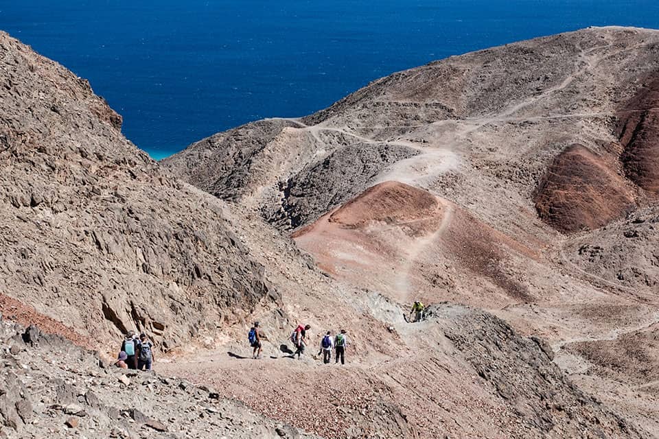
The hike itself begins here, where the riverbed starts carving into the black granite. Some lovely examples of the toothbrush tree (Salvadora persica in Latin and salvadora parsit in Hebrew) grow in the riverbed. Further along is a large concentration of fig capers (Capparis inermis Forssk or Capparis sinaica in Latin and zalaf sehusi in Hebrew) that managed to survive the floods that sweep down the riverbed from time to time. (Please note that this riverbed should not be entered when there is a flood warning.) The green trail advances along the riverbed, which becomes a narrow canyon flanked by upright walls. Metal handles were installed at several tricky spots to make them easier for hikers. After about an hour of walking in the riverbed, the green trail meets the Israel Trail, which descends into the riverbed via a broad, steep channel (that has both Israel Trail and black trail markings). The Israel Trail joins the green trail on the bank of Nahal Netafim at a point where the riverbed is still a canyon but is broadening. The trail advances toward the foot of a steep slope on the northern bank. The large acacia tree at the bottom of the slope is a great place to rest, refuel, and contemplate the next part of the hike.
One option is to continue from here by following the black-marked trail up the boulder-dotted riverbed. The black trail later exits the canyon via ladders and reconnects to the Israel Trail. The other option is to follow the Israel Trail, which ascends the bank in a swift, dramatic climb to a lookout point that offers an impressive view of the Eilat mountains. About a kilometer after the viewpoint, the trails reconnect and then turns sharply to enter Nahal Netafim again. Here the riverbed carved into gleaming sandstone/limestone and its floor is dotted with rocks of stunning shapes that collapsed into it in the process. After about two kilometers, the trail reaches Ein Netafim, a tiny spring emanating at the foot of an impressive waterfall. Its water drips into a man-made trough. Its Arabic name is Ein al-Katar, which means the spring of drops or the dripping spring. Its water was first harnessed for human use during the British Mandate period when the trough was built. The trough has been destroyed more than a few times since then. Guides from the Eilat field school rehabilitated it in the 1960s and Israel Nature and Parks Authority inspectors have done so several times as well. The riverbed is named after this tiny spring, which is the only constant water source in the mountains of Eilat and attracts herds of gazelles and rock hyraxes. About a decade ago, the water of the spring was fit for human consumption, but it has since become saline, though desert animals still consume it. A handsome concentration of southern maidenhair fern (sa’arot shulamit in Hebrew and Adiantum capillus-veneris in Latin) adorns the cliff above the spring.
The ascent from the bottom of the waterfall may be one of the best reasons to hike this segment of the Israel Trail: a narrow passage through a crevice in the rock with a few metal handles to help. Anyone carrying a large backpack will have to remove it since a hiker and a backpack cannot fit through this crevice together. The most challenging part is at the top, where hikers must maneuver nimbly over a large rock in the crevice to complete the ascent.
The Netafim campsite is above the waterfall. This is a great place for those who are hiking the entire trail at once to spend the night.
The route continues to ascend a dirt road leading from the campsite to Route 12, near the ascent to Mount Yo’ash. The Israel Trail continues on the other side of Route 12. Carefully cross the parking area south of the road to reach the sign declaring that the final segment of the Israel Trail begins there. This segment runs through the Nahal Gishron Riverbed.
The massive fence along the Israeli-Egyptian border was completed several years ago as was a road running alongside it. The route of the Israel Trail, particularly the segment that descends into Nahal Gishron, changed as a result. The new route is much more beautiful than the previous one, which ran directly along the riverbed.
Two hiking trails lead out of the campsite. The trail marked in black follows the route of Derab al-Haj, the pilgrims’ route to Mecca. Despite a few ancient leopard traps near that route, this hike chooses the second option: following the Israel Trail, which continues from here along with a route that has blue trail markings. This route bypasses Mount Yo’ash, proceeding along its dramatic hogbacks from the west, and then descends to a layer of shockingly red sandstone. The route continues at the same height as if the path were carved into the red stone. It is a short walk to the Gishron Ali viewpoint, which is located slightly above the trail on the black-marked trail mentioned earlier.
The Gishron Ali viewpoint offers one of the most dramatic views in the Eilat mountains. Deep below it is the Nahal Gishron Riverbed, with the border fence and the border road winding through the narrow, black canyon in an impressive example of engineering work. Beyond it, the Sinai and Gulf of Eilat can be seen.
There are two options for how to continue from the viewpoint, depending on how much time remains until sunset. If there are at least three more hours of daylight, continue along the new route of the Israel Trail that was marked after the border fence was completed. This route descends into the riverbed and includes several challenging descents along with metal ladders as well as descending the big waterfall in Nahal Gishron.
Shortly after the waterfall, the Israel Trail continues in one direction and a red-marked trail continues in a different direction. After a short walk, the red trail joins a green trail, ascends to the northwest, passes over a small shoulder, and reaches the upper Nahal Shelomo campsite, where the first day of this hike concludes.
The second option is shorter and more interesting. It involves descending along the black-marked trail that parts ways with the Israel Trail slightly before the ascent to the viewpoint. This path descends into the stunning sandstone expanses whose stripes of red and white resemble a hug layer cake. The path descends in a broad channel and makes its way toward Route 12. However, slightly before it seems to have reached the end, it instead reaches a waterfall and handsome hogbacks that actually are the southern edge of Mount Yo’ash. Hogbacks form on sharply inclined layers of rock. The angle creates expanses that are almost vertical so that the sediments along them peel away parts of layers in the form of triangles. Tomorrow’s route passes many hogbacks.
The path descends, with the help of a series of metal handles, along a layer of stone that is almost vertical. After this descent, the trail continues toward the big curve in Route 12. This is a good place to arrange to meet cars (there is a large parking lot next to the highway) to take tired hikers to a hotel in Eilat. Another option is to continue carefully alongside the highway for 1.5 kilometers to reach the upper Nahal Shelomo campsite and spend the night there.
Day Two – Dramatic End of Trail
The Israel Trail’s final segment, from the upper Nahal Shelomo campsite to Eilat, is without a doubt one of its most beautiful. There are two options for the start of the hike. The longer option is to return from the campsite along the green path to Zafra Pass. Then continue through the water conveyor/waterworks (once hikers had to crawl to get through the narrow crevice in the rock) to the Israel Trail, which descends into Nahal Gishron. The route includes climbing a three-meter waterfall and the steep Gishron ascent.
However, the steep climb is not mandatory. Another option is to descend from the campsite on the bank of Nahal Shelomo and then to turn onto the green-marked trail in the Nahal Yehoshafat Riverbed and follow it to the blue-marked trail, which ascends to the top of the Gishron ascent.
Another option is to drive down the bank of Nahal Shelomo on the red-marked trail to the Nahal Rehav’am Riverbed and then to drive along the blue-marked trail to the roadblock before the road paved alongside the border. Part from the car and driver there and begin the hike on foot. Those who did not sleep at the campsite or who simply wish to hike only this part can reach it by car on the road ascending from Eilat through Nahal Shelomo to the big campsite at Nahal Shelomo. The road passes a camel ranch and then can be followed to the campsite and beyond it to the turnoff into Nahal Rehav’am and the roadblock.
All of the options mentioned above lead to this path, which climbs an ascent dotted with large bulblike limestone masses to the top of the Gishron ascent. This is a great spot to gaze at Nahal Gishron in all its glory as it winds down the slope below as well as the Sinai landscape. After taking in the view, walk south on the Israel Trail along a handsome spur between Nahal Rehav’am and the cliffs that descend into Nahal Gishron, the Gishron cliffs. However, before continuing forward toward the end of the Israel Trail, take a slight detour to Hill 342. An unmarked path leads to its summit. The ascent is a bit steep but worth the effort. The summit offers a panoramic view of the entire area, mainly the Rehav’am Valley with Mount Rehav’am in the middle of it, to Mount Shelomo and its brothers, which are named after the kings of Judea. Descend from the hill and continue following the Israel Trail and the black-marked trail southward. This route leads past a huge bulblike flint mass that was split in two. The quartz masses, which the bulb formed around, glitter from what was its interior. A few meters after that, the trail reaches the security road along the border. The Israel Trail continues to the other side of the road. However, before following it, those who started on the shorter route can take the time to walk along the black trail that also starts on the other side of the road. This path ascends the Gishron cliffs to an amazing lookout point over the Sinai. The path no longer continues beyond there, so hikers must retrace their steps back to the beginning by the road, but the view is worth this slight deviation from the main route.
Return to the Israel Trail, which is marked in red at this point. The path descends into the valley and starts to climb Nahal Gishron’s northern bank above a huge cliff whose layers came to rest at 70-80 degree angles some 100 meters above the riverbed’s floor. This series of hogbacks is part of the sandstone ridge separating Nahal Gishron from Nahal Zefahot. The hogbacks, which look like they were designed by an artist, adorn the cliff, with a wall that is almost vertical descending from the path above it that leads into the riverbed.
The climb ends at a spot that offers a view of the Eilat mountains. The trail then continues toward Mount Zefahot. The short segment of the Israel Trail that remains has been nicknamed the Knife Ridge Trail because it runs along the crowns of the hogbacks – it is a narrow path with deep and steep abysses on either side. The crowns of the hogbacks offer a view of the Mountains of Edom, the Gulf of Eilat, the Jordanian city of Aqaba, and the mountains in Sinai.
Once, before the border was defined and fenced, the trail descended to Nahal Gishron and ascended in a small channel dotted with bulblike limestone masses. The upper edge of the ascent as well as dozens of the round masses still can be seen today to the right of the trail.
The path now continues toward the final challenge on the Israel Trail. After an easy walk in the wide, flat Nahal Zefahot, the black trail that the Israel Trail had been following meets a green-marked trail that began at the campsite in the lower part of Nahal Shelomo. The Israel Trail continues with the green trail, which now makes a sharp right and climbs through a schist channel to reach Mount Zefahot’s summit. It is a steep climb and towards the end there is another climb before the summit, but from the top, there suddenly is a view of Gulf of Eilat and the city of Eilat, which is directly below, as well as of Aqaba on the other side of the gulf. Four countries actually can be seen from the summit: Israel below, Jordan beyond the gulf and Saudi Arabia to its south, and Egypt on the other side. To the south, the coral formations can be seen opposite the shores of Sinai.
Several trails descend from Mount Zefahot to the beach in the Gulf of Eilat. The Israel Trail markings lead along a route of natural steps that descends toward the Eilat field school. After the first section of the descent, a black-marked trail leads southward. This is a beautiful, steep, difficult route toward the diving village on the Eilat beach. Another trail, with blue markings, descends along an easier route to the traffic circle and gas station on the main road. The trail is easier, but the conclusion, in an area with construction waste and industrial ruins, is not the right way to conclude a journey along the Israel Trail. The other trail that descends from the mountain is marked in red and turns southward. This handsome stretch of trail actually was the original conclusion of the Israel Trail. Today, however, it is forbidden to hike along this trail due to its proximity to the border fence.
The Israel Trail thus ends at the fence of the Eilat field school. A large stone on which the trail colors were painted indicates its end. The sign marking the end of the trail is a few hundred meters further on inside the field school’s grounds. It is a pity that the sign was not placed at the ending point or that a handsome new sign was not placed there to symbolize for hikers that they have completed the 940-kilometer hike from the Dan to Eilat.